
- #HGCREATORS
- #HGEXPLORE
- #HGVOICES
- #HGSHOP
- CAREERS
- ABOUT US
- CONTACT US
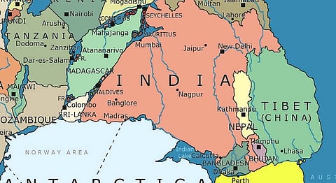
Florida takes centre stage in artist Massimo Pietrobon’s speculative interpretation of the world map in the Paleozoic era, while Canada, Greenland and Western Europe nestle in a friendly group huddle. This image of the supercontinent is an amusing and fairly imaginative look at what the world would be like if Pangea hadn’t broken up approximately 300 million years ago.
The very basis of the world map as we know it having been uprooted, the possibilities in a world like this would now be quite endless. You could literally line dance from Rio de Janeiro to Angola now, if you ever felt so inclined. How about getting some chai, chess and newspaper-reading in Kolkata only to carry on that heated political discussion in Perth, because Australia has now officially joined the party in the supercontinent?
Russia and China now find themselves clumped together, segregated slightly from the rest of the world by oceanic barriers, while New York is so much closer to Moroccan goodies, no more separated by the North Atlantic Ocean.
North Korea and South Korea are now basically rubbing shoulders (awkward) and India should probably demand a recount with its land being scattered in two far-flung locations—one part near China and the other closer to Australia, which just happens to be too cold for Kangaroos.
This map really turns things on its head. The Indian Ocean is now Indian Lake, and a trip from Karachi to Nairobi would constitute the makings of a fairly enjoyable road trip.
If you think Canadians are extremely nice now, try adding some tropical sunshine to the mix.
While the map takes some liberties with places like Hawaii, Iceland, the Sumatra and Java islands, and of course our very own Himalayas that were all formed volcanically and hence wouldn’t have existed in the Paleozoic, according to this map, you would be able to enjoy a dosa in Chennai while waving at your neighbours in the Antarctic.
One way or the other, we’re glad Pietrobon had enough time on his hands to create this playground map for the rest of us.


Image Credit: www.npr.org and www.mic.com
If you liked reading this we suggest you read: