- HOMEGROWN WORLD
- #HGCREATORS
- #HGEXPLORE
- #HGVOICES
- #HGSHOP
- CAREERS
- ABOUT US
- CONTACT US

Google has become one of the leading map-makers in the world. Elisabeth Sedano, a lecturer of the Spatial Sciences Institute at the University of South California, explains, “any borders are social constructs,” and therefore, there cannot be any physical features to differentiate between where borders should and shouldn’t be.
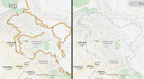
When it comes to the much-disputed Kashmir border between India and Pakistan, The Washington Post reports,
“Both sides claim the Himalayan outpost as their own, but Web surfers in India could be forgiven for thinking the dispute is all but settled: The borders on Google’s online maps there display Kashmir as fully under Indian control. Elsewhere, users see the region’s snaking outlines as a dotted line, acknowledging the dispute.” From Pakistan, the region is shrouded in dotted lines confirming the dispute in their country.
Outlook India also reported a discrepancy regarding the mapping of this particular border from elsewhere, “When Jammu and Kashmir is searched from India on Google Maps, it displays a solid grey outline bordering the region and showing it as part of the country. However, when searched from a location outside of India, such as in Europe, Outlook found the lines appeared dotted.”
Jean-Christophe Plantain, a researcher from the London School of Economics, writes, “Google Maps has popularised a model of cartography as a platform, in which digital traces are collected through participation, crowdsourcing, or user’s data harvesting and used to constantly improve its mapping service. Based on this capacity, Google Maps has now attained a scale, reach, and social role similar to the existing infrastructures that typically organise cartographic knowledge in society.” Highlighting the fact that Google has now dominated the way in which we view all spatial dynamics. At the mercy of powerful policymakers, diplomats and other authorities with a proclivity for dominating tactics.
According to The Economic Times, a case was lodged against Google Maps for the incorrect representation of international boundaries, it was also followed by the Survey of India. The Geo-Spatial Bill Regulation Bill of 2016 also makes it mandatory for every person and organisation to acquire the Government’s full permission before publishing any spatial information.
The Indian government has full jurisdiction to refute what an external agency such as Google showcases on its map-tracing platform when it comes to the representation of India’s borders. But, this cannot be extended to other countries as it is beyond the Government of India’s jurisdiction. Google uses respective spatial data provided by each country and its local bodies to remain fully non-partisan. Google’s method of techno-governance is to be questioned especially since they try to hold a neutral position.
According to RBC analysts, Google profits massively from their map-creating software. Under pressure from local laws and official bodies that help make the business at Google so profitable, staying neutral, becomes vital for the tech giant.
If you enjoyed reading this article, we suggest you also read:
